(click on images below to enlarge)

Mapping
- New River Valley Green Infrastructure Network
- Water Resources
- Forest and Farming Lands
- Natural Hazard Areas
- Habitat and Ecosystem Diversity
- Recreation and Health
- Cultural Heritage
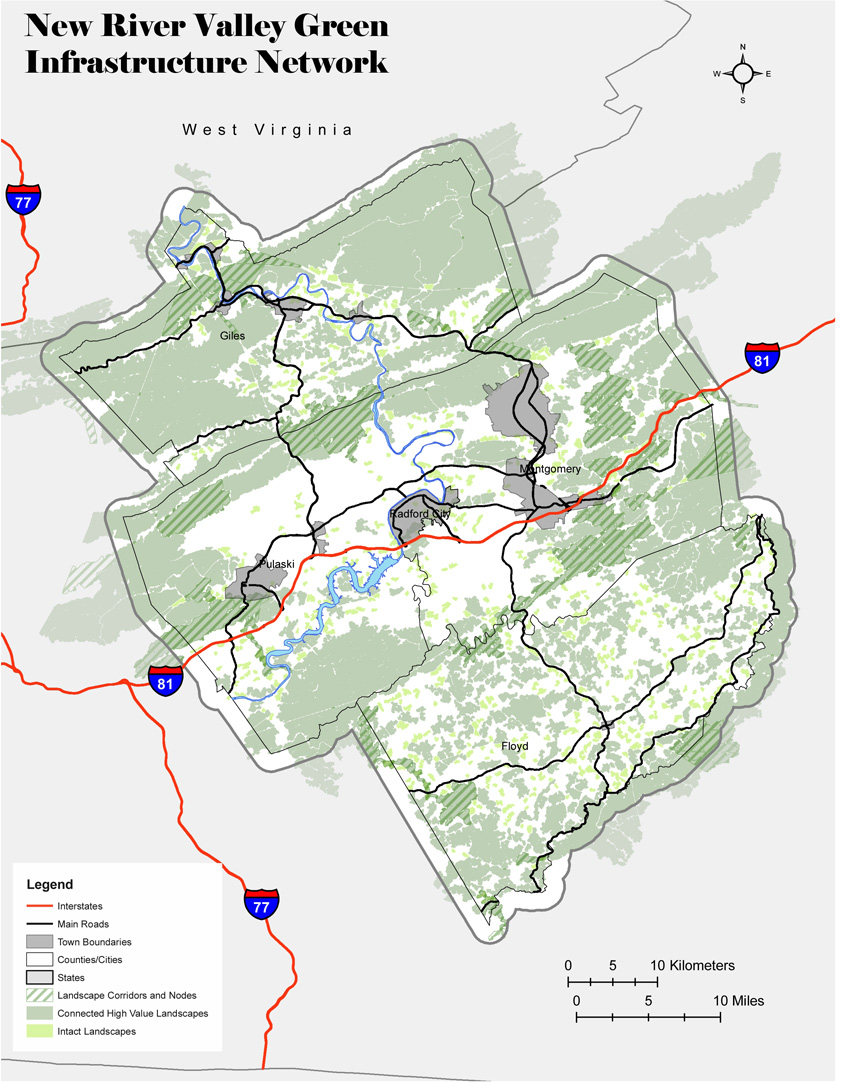
New River Valley Green Infrastructure Network
The New River Green Infrastructure network will promote sustainable growth and development that protects the value and function of critical ecological features, the cost-effective services they provide, and significant cultural and historic areas.
To provide the most objective picture of natural assets in the NRV, the steering committee chose to use methods developed by the Green Infrastructure Center, Inc. of Charlottesville, Virginia. These methods included utilizing data from the Virginia Department of Conservation and Recreation's Virginia Conservation Lands Needs Assessment. The base map (in the sidebar) consists of the Virginia Natural Landscape Assessment database that factor many criteria to determine the "Ecological Integrity" of lands. Open lands are given an ecological integrity score based on size of a core, type of land cover, among other criteria. These criteria were developed by a working group of scientists, biologists, foresters and others brought together by DCR.
The NRV base map takes the statewide database and makes several minor adjustments, such as re-ranking the significance of the cores for the region rather than the state. Because the initial assessment was based on data from 2000, the dataset was compared with aerial photography taken in 2007. For the NRV, there were no changes to be made based on land use changes between 2000 and 2007.
Data: Map produced by Conservation Management Institute (2009)
Virginia Dept. of Conservation and Recreation. Virginia Natural Landscape Assessment. (2006). http://www.dcr.virginia.gov/natural_heritage/vclnavnla.shtml
(back to top)
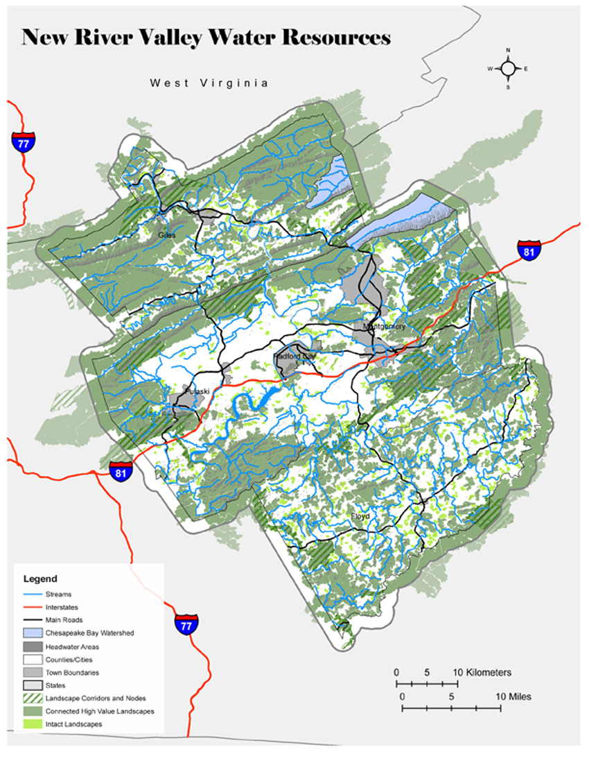
Water Resources
Protect and enhance the water resources of the New River Valley, including watersheds, wetlands, groundwater, and source water area, to protect water quality, and provide a continually safe and abundant water supply for its citizens.
During a series of five community meetings held in 2007, water quality and water issues were the issue of most concern for residents. Water resources are abundant in the NRV, but they are vulnerable to pollution.
The water resources map includes all second order and higher streams in the NRV. Situated along the Eastern Continental Divide, the NRV also has many areas considered headwaters areas, or high ridges where precipitation run-off gathers to form headwaters streams. These headwaters areas are critical to protect as natural areas because they provide significant pollution protection to the headwaters streams located there. As cleaner water flows downhill, the larger order streams are also cleaner due to these headwaters areas. The headwaters areas were delineated by finding the top 10% of elevations in the region using a hill-shading analysis in ESRI ArcGIS.
Wetlands function as critical habitat for wildlife, as well as act as a natural filter for surface water. Preserving wetlands aids in the improvement of water quality by sequestering excess nutrients and sediment, as well as mitigating flooding effects.
Data: Map produced by NRVPDC (2009)
US Fish and Wildlife Service. National Wetlands Inventory. (2009). http://www.fws.gov/wetlands/
US Geological Survey. National Elevation Dataset. (2009). http://ned.usgs.gov/
US Geological Survey. National Hydrography Dataset. (1999). http://nhd.usgs.gov/
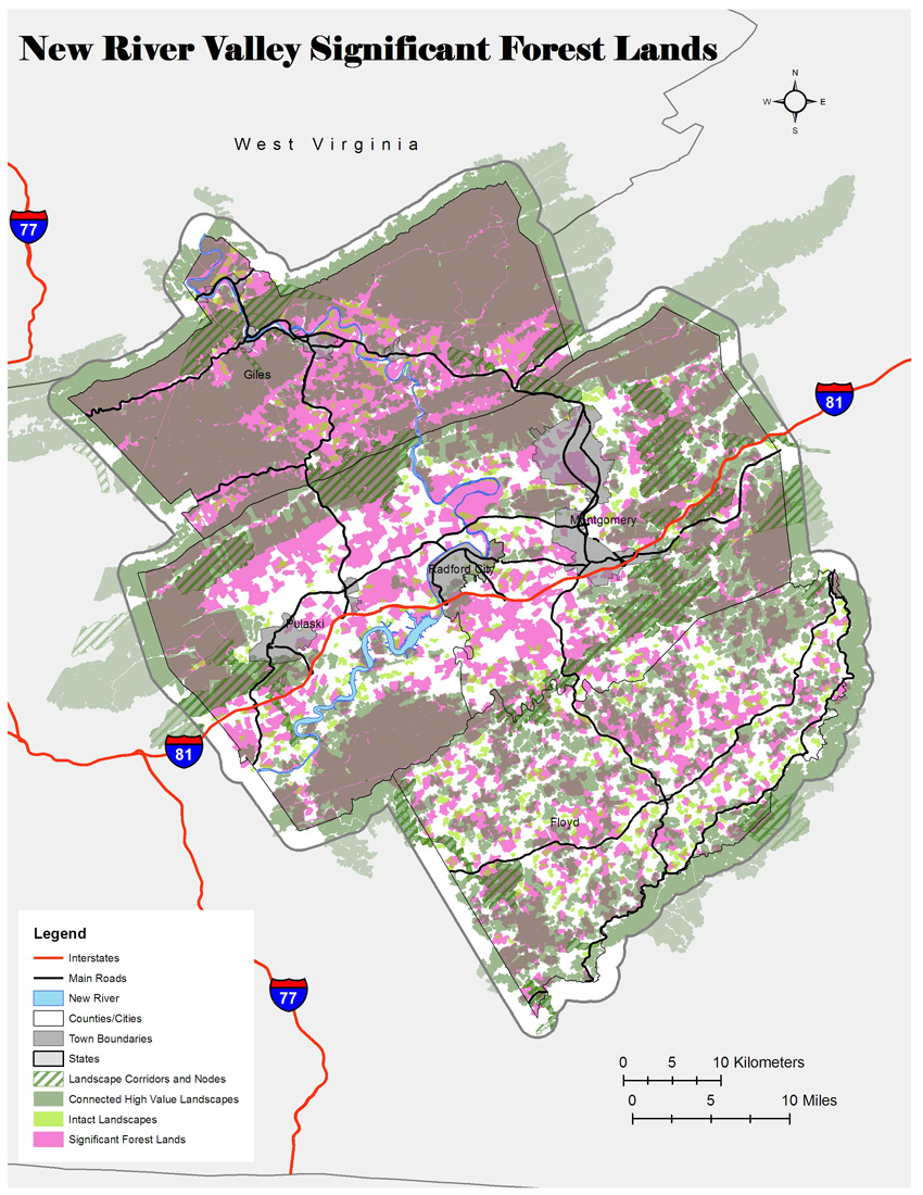
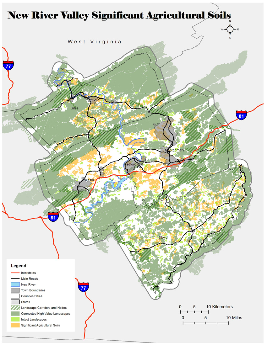
(back to top) Forest and Farming Lands
Protect the working landscapes of the New River Valley, including its forests and agricultural lands to provide a source of regional economic support and maintain the regions rural character.
Forests
Working lands in the NRV are comprised of two primary types: forest and agricultural. Much of the forested lands in the region were identified in the VALNA used to generate the base map. Additional lands were identified using the VA Department of Forestry's Forest Cover dataset. Forested lands were filtered to include only parcels larger than 100 acres. 100 acres was used as the threshold because at that size, sustainable forestry practices are economically feasible and there is opportunity for the parcel to serve additional ecological purposes (such as wildlife habitat, water run-off filtration).
Agriculture
Agricultural lands in the NRV were identified using soil classifications and then filtering for parcels larger than 100 acres. Agricultural soils were identified from soil surveys conducted by the US Geological Survey. The USGS identified various classes of soils on a national scale and included additional classes of soils based on state definitions. From the national classes, Class I and II soils were selected, and from the state classes all soils labeled as Prime Farmland and Farmland of State, Local, or Unique Significance were selected. Again, the 100 acre minimum threshold was chosen because at that size sustainable agriculture is economically feasible on a larger scale and it was the minimum size for conservation easements to be accepted by Virginia Outdoors Foundation at the time.
Data: Maps produced by Conservation Management Institute (2009)
Forests:
Virginia Dept. of Forestry. Virginia Forest Cover. (2005). http://www.dof.virginia.gov/gis/datadownload
Virginia Dept. of Forestry. Virginia Land Use. (2005). http://www.dof.virginia.gov/gis/datadownload
Farms:
Virginia Dept. of Forestry. Virginia Land Use. (2005). http://www.dof.virginia.gov/gis/datadownload
Natural Resources Conservation Service. SSURGO Soils Database. (2009).
http://soildatamart.nrcs.usda.gov/
(back to top)
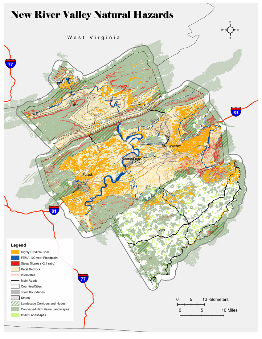
Natural Hazard Areas
Protect human life and property in the New River Valley by identifying potential natural hazard areas, such as floodplains, steep slopes, unstable soils, and karst areas, for special consideration during development discussions.
Several land features prominent in the region can pose significant problems to development, but when identified before development these features can be a consideration to conserve areas for open space. Specifically the natural hazards identified to be given consideration include flood plains, steep slopes (greater than 2 to 1), highly erodible soils, and karst geology. The slope threshold and criteria for erodible soils was recommended by VA DCR engineers based on the Virginia Erosion and Sediment Control Handbook. Karst geology is identified by carbonate bedrock which is readily dissolved by water. In karst, precipitation run-off moves quickly through an interconnected underground system of caves, making groundwater in the area particularly vulnerable to pollution.
Data: Map produced by NRVPDC (2009)
US Geological Survey. National Elevation Dataset (2009). http://ned.usgs.gov/
Federal Emergency Management Agency. Digital Flood Insurance Rate Maps. (2009). http://www.msc.fema.gov/
Natural Resources Conservation Service. SSURGO Soils Database. (2009).
http://soildatamart.nrcs.usda.gov/
(back to top)
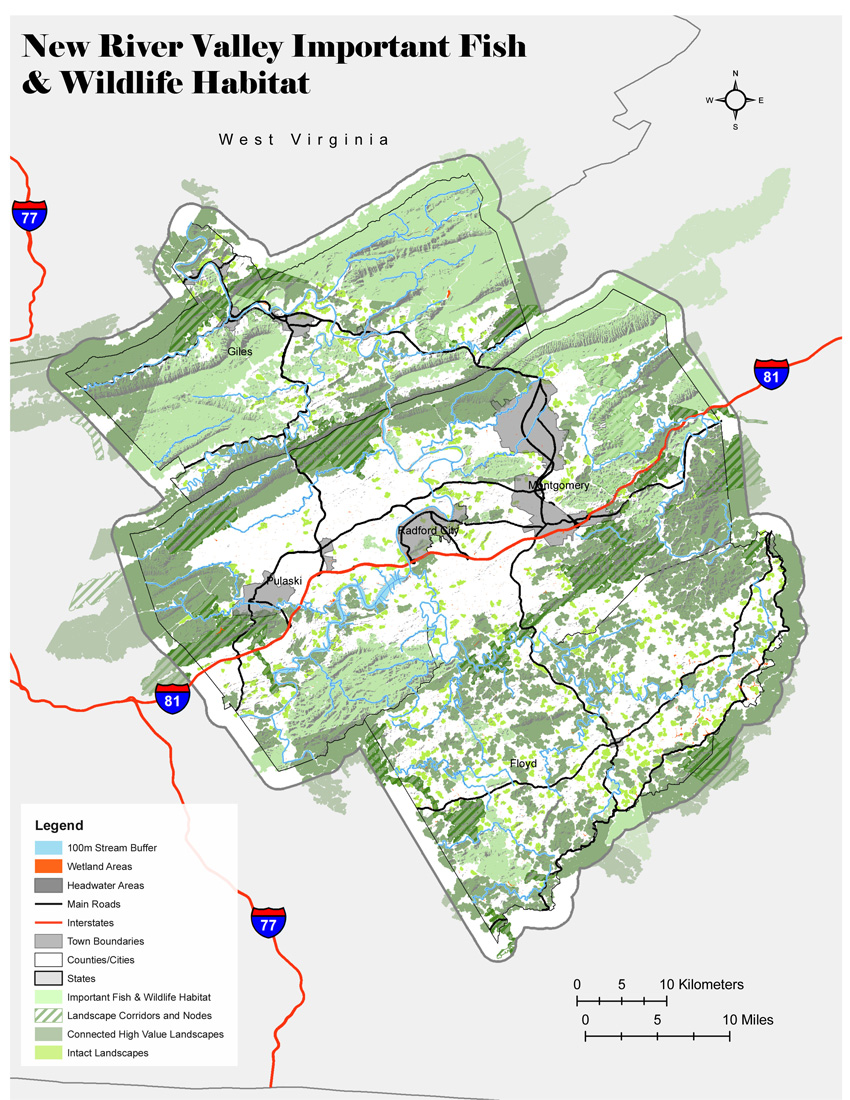
Habitat and Ecosystem Diversity
Protect and enhance the natural landscapes and biodiversity of the New River Valley, to provide habitat for the region's plant communities, wildlife and fisheries, including unique ecological communities and rare, threatened, or endangered species, and other areas of environmental concern.
One of the many benefits of open, natural areas is the habitat provided for fish and wildlife. The habitat map was developed using the advice of wildlife biologists and other experts. These experts recommended using data identifying important habitat for numerous species. To have the most positive impact for fish and wildlife, it was recommended to identify headwaters areas and riparian buffers that serve to improve water quality downstream and provide corridors for wildlife movement. Additionally, wetlands provide a remarkable amount of habitat and provide stop-over locations for migrating bird species.
Data: Map produced by NRVPDC (2009)
Virginia Dept. of Conservation and Recreation. Natural Heritage Screening Coverage. (2008). http://www.dcr.virginia.gov/natural_heritage/nhdeinfo.shtml
US Fish and Wildlife Service. National Wetlands Inventory. (2009). http://www.fws.gov/wetlands/
US Geological Survey. National Elevation Dataset. (2009). http://ned.usgs.gov/
Virginia Department of Game and Inland Fisheries. Tier-I and Tier-II Species Richness. (2008). http://www.bewildvirginia.org
(back to top)
Recreation and Health
Protect and enhance parkland, open space, connecting land and water corridors of the New River Valley, to provide for outdoor recreation opportunities, such as fishing, hunting, wildlife viewing, paddling, camping, and trail-based activities.
Outdoor recreation is a key part of life in the New River Valley, especially with the National Forest close-by and the Appalachian Trail traversing the region. These recreational activities often provide additional societal benefits when they coexist with conserved open spaces. This map provides a basic inventory of the various outdoor recreational facilities available to the public in the region. There are additional facilities (including local trails and parks) that are not visible at the regional scale, but provide similar ecological and societal benefits.
Data: Map produced by NRVPDC (2009)
Appalachian Trail Conservancy. Appalachian Trail GIS and GPS Data. (2009). http://www.appalachiantrail.org/site/c.mqLTIYOwGlF/b.4805623/k.438D/
Appalachian_Trail_GIS_and_GPS_Data.htm
Virginia Dept. of Conservation and Recreation. Conservation Lands Dataset. (2009). http://www.dcr.virginia.gov/natural_heritage/cldownload.shtml
Virginia Dept. of Game and Inland Fisheries. Maintained Boating Access Locations. (2009). http://www.dgif.virginia.gov/gis/gis-data.asp
US Forest Service. George Washington and Jefferson National Forest Dataset. (2009). ftp://ftp2.fs.fed.us/incoming/r8/gwjeff/GIS/
(back to top)
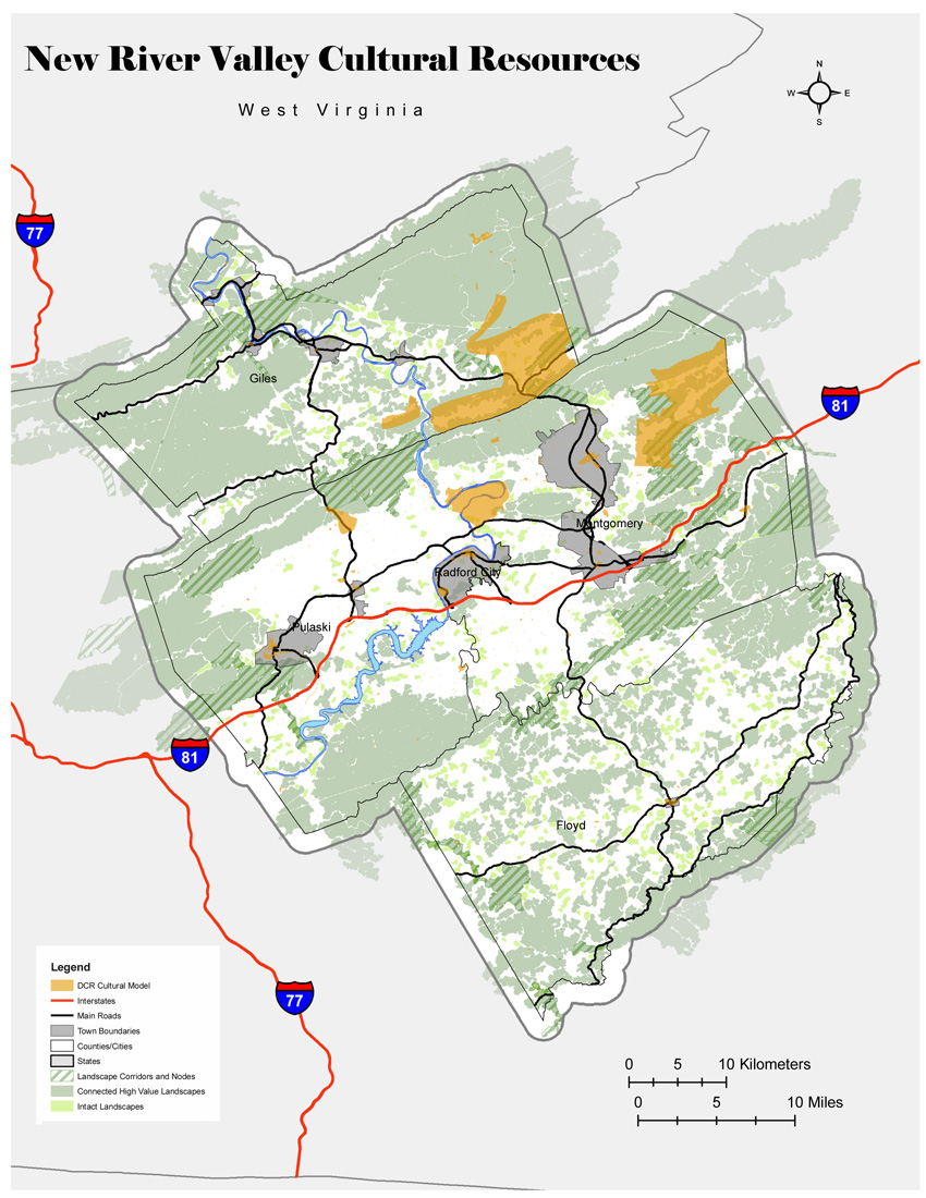
Cultural Heritage
Protect significant cultural sites, historic and archeological resources, and scenic viewsheds of the New River Valley, to provide an opportunity to continue to tell the stories of our nation's past, and the settlement and growth of the New River Valley region.
Cultural Resources
As a part of the Appalachian Region, culture is a large part of what defines the New River Valley. These maps were produced to identify those cultural assets that create a sense of place for residents and visitors to the region. Specifically, the cultural model from VA DCR was used to identify significant historic, architectural, archaeological, and cultural resources.
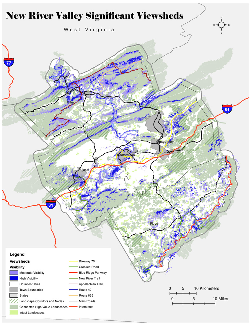
Viewsheds-Combined
Viewsheds are areas of particular scenic or historic value that are readily visible from public areas such as from public roadways or public parks. To create this map, several important cultural assets in the region were identified, including the New River and the Appalachian Trail, among others. Then using a spatial analysis tool in ESRI ArcGIS the viewsheds from these features were identified. Keeping these identified areas as open spaces will only increase the aesthetic value in the region.
Data: Maps produced by NRVPDC (2009)
US Geological Survey. National Elevation Dataset. (2009). http://ned.usgs.gov/
Virginia Dept. of Conservation and Recreation. Virginia Conservation Lands Needs Assessment Cultural Asset Model. (2006) http://www.dcr.virginia.gov/natural_heritage/vclnacultural.shtml
(back to top)