NRV Mapping of Vulnerable Roadways and Outreach Campaign


Project Overview

The primary goals of the New River Valley Mapping of Vulnerable Roadways and Outreach Campaign are three-fold:

  1. GIS mapping of vulnerable roadways and bridges
  2. Education and outreach
  3. Implementation of mitigation strategies

This webpage provides more information about each project goal. Visit the site frequently to stay up to date!

sign

Goal 1:

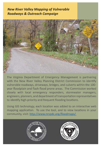
Identify vulnerable roadways, driveways, bridges, and culverts within the 100-year floodplain and flash flood prone areas. To get started, the Commission utilized GIS technology to identify each of the bridges and roadway segments that intersected with floodplain data. Second, the Commission met with local emergency responders, stormwater managers, engineers, planners, and department of transportation representatives to identify the high-priority/frequent flooding locations.

Once the high-priority locations were identified, the Commission performed field visits at each site. Inspectors took photos and documented existing conditions such as: the presence of water, visible signs of erosion, and existing signage or other permanent mitigation measures. The information was later entered into a geodatabase.

The geodatabase offers local stakeholders and Virginia Department of Emergency Staff the ability to review each location in detail, through the use of an interactive web mapping application. To use the tool, simply hover over any participating locality and click within the highlighted area. You can click on a location or photo and view the full report for each site.


Click on the map to explore the conditions of the identified locations for each counties.


Goal 2:

This project incorporates the National Oceanic and Atmospheric Administration’s Turn Around – Don’t Drown program. The program consists of creating education and outreach efforts targeted towards citizens who rely on the region’s vulnerable infrastructure. The primary outline of the program is to:

  • Encourage drivers to avoid areas already flooded, especially if water is flowing fast.
  • Do not attempt to cross flowing streams. Turn Around Don’t Drown.
  • Six inches of moving water can make a person fall. In addition, six inches of water will reach the bottom of most passenger cars causing loss of control and possible stalling.
  • Twelve inches of water will float many vehicles.
  • Twenty four inches of water can carry away most vehicles, including SUVs and pick-ups.

The Commission is currently developing materials for distribution to citizens, fire and rescue departments, and other local government departments that frequently interact with citizens on the topic of stormwater. In addition, the Commission is working with local stakeholders to identify the best means of educating people who may move into vulnerable areas after the project is complete.


rack_card

Goal 3:

As a result of documenting vulnerable transportation infrastructure and receiving public feedback through the education and outreach campaign, funding is available for permanent roadway signs. The Commission plans to work closely with local stakeholders, the Virginia Department of Emergency Management, and the Virginia Department of Transportation to identify appropriate signage design and location.