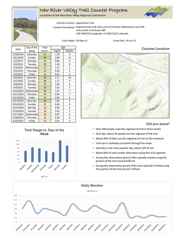
NRV Trail Counter Program


Program Overview

The New River Valley Regional Commission launched a trail counter program in July 2014 and localities were asked to help identify count locations for the ongoing project. The purpose of the NRV Trail Counter Program is to help member jurisdictions:

  • Measure trail usage (along a specific segment, at a trail head, or near businesses)
  • Identify patterns (e.g. weekday vs. weekend)
  • Evaluate the effects of weather, terrain, and other physical features
  • Delineation between user types (cyclist, pedestrian, horseback, etc.)
  • Identify potential investment strategies


hike

A photo taken during a trip to Mill Creek trails in Giles County.

Trail Counters

The program uses a small infrared trail counter to record human activity. The counter is hidden, usually in a tree, approximately three feet back from the trail and is left there to record data for one month. It is positioned pointing across the trail to count general traffic.

The instrument is designed to count warm, moving objects and continually monitors the infrared energy within its field of view. A count is recorded when there is a significant change in energy, such as a passing cyclist.

The infrared trail counter has some limitations. Normally two people walking side by side generates a single count. Also depending on its placement, the counter can record unwanted animals or vehicles within its view.


counter

A photo of the infrared trail counter used in the program.

Map Tour

Use the map below to explore locations in the Trail Counter Program.


Report Finder

Select a trail name from the dropdown menu to view a list of available trail count reports. Click on the resulting link(s) to view a downloadable PDF of the report.


Available Reports


AT

An example showing the Appalachian Trail count report.